Q 25 / 25
UPSC CSE Prelims 1997
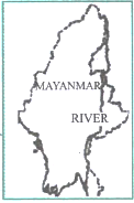
Consider the map given below: The river shown on the map is:
EXPLANATION
Correct Option
The map illustrates a major river flowing through the eastern part of Myanmar. This river is identified as the Salween River.
- Originating in the Tibetan Plateau, the Salween flows southward through China's Yunnan province, eastern Myanmar, and eventually discharges into the Andaman Sea.
- It constitutes a significant portion of the Myanmar-Thailand international border, particularly in the Shan Plateau region.
- The Salween is one of Southeast Asia's longest rivers, known for its relatively less developed and dammed basin compared to other major regional rivers, contributing to its ecological importance.
Incorrect Options
-
(a) Irrawaddy: This is the principal river of Myanmar, but its course lies predominantly in the central-western part of the country, not the eastern region depicted on the map.
-
(b) Mekong: The Mekong River flows through several Southeast Asian countries including Laos, Cambodia, Vietnam, and along the eastern border of Thailand. It does not flow through the interior of Myanmar as shown.
-
(c) Chao Phraya: This river system is located entirely within Thailand and does not extend into Myanmar.